Typhoon Emong 2025 has officially entered the Philippine Area of Responsibility (PAR), according to the latest PAGASA forecast. Here’s everything you need to know about the storm’s track, wind signals, and safety updates.
SOURCE: newsinfo.inquirer.net
📌 Latest PAGASA Update – July 24, 2025 – Typhoon Emong 2025
As of 5:00 PM today, Typhoon Emong was located at:
- 📍 Location: 285 km East of Baler, Aurora
- 🌬️ Maximum Winds: 85 km/h near the center
- 💨 Gustiness: Up to 105 km/h
- 🌀 Movement: West Northwest at 15 km/h
PAGASA has raised Tropical Cyclone Wind Signal #1 over several parts of Northern and Central Luzon, including:
- Aurora
- Isabela
- Nueva Vizcaya
- Cagayan (southern portion)
- Northern Quezon (incl. Polillo Islands)
SOURCE: newsinfo.inquirer.net
🗺️ Emong Typhoon 2025 Track
📉 Forecast Track:
| Date/Time | Location | Strength |
|---|---|---|
| July 24, 8:00 PM | Near Casiguran, Aurora | Tropical Storm |
| July 25, 2:00 AM | Approaching Northern Luzon coastline | Possible Typhoon |
| July 25, PM | Exiting landmass toward West PH Sea | Weakening trend likely |
You can track Typhoon Emong live via:
👉 PAGASA Typhoon Tracker
👉 Windy.com – Typhoon Emong Tracker
🚨 Safety Tips During Tropical Cyclone Wind Signal #1
- Stay updated via radio or mobile alerts
- Charge power banks and secure flashlights
- Avoid traveling to elevated or low-lying flood-prone areas
- Keep emergency food and water supply
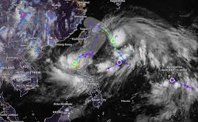
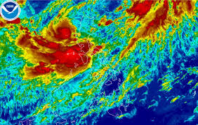
📷 What Does Emong Look Like Now?
Typhoon Emong is forming a wide cloud band, bringing heavy rainfall to Aurora, Isabela, Quezon, and parts of Bicol and Eastern Visayas. Light to moderate rain is expected in Metro Manila later tonight.
📅 When Will Typhoon Emong Leave PAR?
PAGASA forecasts that Emong will exit PAR by Friday evening or Saturday morning, depending on its speed. After that, it may continue toward the South China Sea, weakening as it interacts with land.