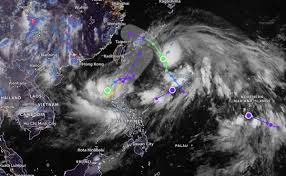
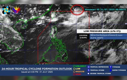
A Low Pressure Area (LPA) currently located outside the Philippine Area of Responsibility (PAR) is being closely monitored by the Philippine Atmospheric, Geophysical and Astronomical Services Administration (PAGASA). According to the latest 4 PM bulletin on Thursday, the LPA is showing a high chance of developing into a tropical cyclone within the next 24 hours.
🌊 Where is the LPA Now?
As of July 31, 2025, the LPA was spotted approximately 965 kilometers east-northeast of extreme Northern Luzon. It remains outside PAR for now, but PAGASA reports that the system is likely to enter the PAR and then quickly exit shortly after.
If the system strengthens into a tropical depression, it will be given the local name “Fabian”, following PAGASA’s tropical cyclone naming list for 2025.
🌀 Will It Affect the Philippines?
PAGASA weather specialist Leanne Loreto stated that no direct impact is expected from this LPA. Even if it develops into a cyclone, the system is anticipated to remain away from Philippine landmass.
However, as it nears the region, it may enhance the southwest monsoon (Habagat), bringing increased rains and thunderstorms to various parts of the country.
☔ Rainy Weather in Several Areas
While the LPA itself poses no direct threat, the prevailing southwest monsoon will continue to affect several regions, particularly in Northern and Central Luzon. The following areas are expected to experience scattered rain showers and thunderstorms:
- Ilocos Region
- Batanes
- Babuyan Islands
- Apayao
- Abra
- Benguet
- Zambales
- Bataan
- Nueva Ecija
- Tarlac
- Pampanga
Meanwhile, localized thunderstorms and isolated rain showers are also possible in other parts of the country due to the continued presence of the southwest monsoon.
🔮 More Cyclones Expected in August
PAGASA has also forecasted 2 to 3 tropical cyclones for the month of August 2025. While their paths remain uncertain, all residents are encouraged to stay alert, especially during the peak of the rainy season.
📌 Stay Informed and Prepared
As we head deeper into the typhoon season, it’s crucial to keep track of official updates from PAGASA and local disaster risk reduction agencies. Even if storms do not make landfall, they can still influence the weather significantly by boosting the southwest monsoon.
Safety Tips:
- Monitor weather alerts regularly.
- Avoid unnecessary travel during heavy rains.
- Secure your home, especially roofs and loose objects.
- Prepare emergency kits with essentials like food, water, and medicines.
- Charge your gadgets and stay connected to reliable news sources.
For official weather updates, visit:
PAGASA Website
Or follow their social media pages for real-time bulletins.